Beam Speeds Wireless

Technology developed in Hawaii opens new possibilities in carrying
data short distances

By Jim Borg jborg@starbulletin.com

A radio beam developed in Hawaii stands to revolutionize high-speed wireless transmissions over short distances, with huge implications for the military, civil defense and fire fighting. Already, it has been adopted by the Coast Guard and the University of Hawaii Institute of Marine Biology for communications to Sand Island and Coconut Island, respectively. And it promises new possibilities for emergency response, battlefield command and control, and communications for islands, ships, aircraft and offshore oil rigs.

Known as advanced millimeter-wave radio, the information beam was developed by Loea Corp., a subsidiary of Trex Enterprises now run by retired Adm. Thomas Fargo, former commander of U.S. Pacific forces. The beam carries information between two points much like a laser, but without the problems lasers encounter with clouds, rain, fog, smog, vog, smoke, sandstorms, explosive debris and other atmospheric clutter. And at one-tenth the cost of fiber-optic cable, it is practical in places where cables are not, says Fargo, Loea chairman.

“There are two fundamental pieces that are important, and one is the ability to move really high amounts of information to connect places where it does not make sense to run fiber,” Fargo said Friday in a telephone interview from Shanghai, where he was on a trade mission with Gov. Linda Lingle.

“The second one is the military application. The military is very expeditionary today, and we’re going to move into places and move out, and in a lot of cases it doesn’t make sense to lay fiber or set up a significant infrastructure. And the demand for information is really high right down to the smallest units, so I’m hoping Loea can help solve those problems.”

art


The technology is so new that it was approved only last year for conditional commercial use by the Federal Communications Commission. The final FCC permit is due to be issued on June 24, said Dan Scharre, Loea president and chief executive. The first generation of Loea commercial transceivers send and receive data at a rate of 1.25 gigabits per second at distances of up to 1.75 kilometers, or almost 1.1 miles. That is enough to carry 50 or 60 television channels.

The Hawaii Institute of Marine Biology, on Coconut Island in Kaneohe Bay, is using a Loea radio to communicate to the UH-Manoa campus through a transceiver at Windward Community College. “We once could make a cup of coffee before we finished downloading a document,” said Jo-Ann Leong, institute director, in a letter to Loea. “We are now able to achieve connection speeds that make distance education a viable opportunity out here, and high-speed computing connectivity with the Manoa main campus computers and the Maui super computing system is now a reality.”

The Coast Guard has two redundant lines for communications between its District 14 headquarters in the federal building and operations across Honolulu Harbor. “It’s basically a large data pipe, a virtual pipe, that carries all types of communications,” said Cmdr. Chris Meade. In an interview Friday, Meade and fellow communications officer Cmdr. Marc Sanders said the Loea system will be employed in a post-9/11 initiative to coordinate emergency communications between the Coast Guard and other government agencies, including the Department of Justice, Navy, Civil Defense, Honolulu Police and Fire departments and the Federal Fire Department.

Formed in May 2001, Loea was built on parent-company research spun off from 1990s contracts with the Pentagon’s Ballistic Missile Defense Organization, now the Missile Defense Agency. An early goal was to set up laser communications between Haleakala and the high-technology research park in Kihei. But lasers — sometimes called “free-space optics” to differentiate them from fiber optics, in which light travels in a cable — work best in clear weather.

Frequent clouds around the 10,023-foot-high Haleakala summit made lasers impractical because the beams are easily scattered by atmospheric water vapor, much as a cloud splits the sun’s reflection into a rainbow. So Trex scientists explored a new area of the electromagnetic spectrum. What they found, they hope, is a pot o’ gold.

Millimeter-wave radio occupies bandwidths shorter than shortwave radio but longer than microwaves and infrared waves, the signature of heat. “In December 2001 we set up a 1-gigabit-per-second link from the rooftop of the Maui research and technology center up to a radio tower on Haleakala, 10 miles as the crow flies,” recalls John Lovberg, chief technology officer for Loea. “Laser technology would not have been able to do the link, but millimeter-wave radio was able to do the link at the same data rate. We then went to the FCC and asked for the spectrum to do this commercially.”

The FCC, after its usual public-comment process, approved in January 2004 the bandwidths of 71 to 76 gigahertz and 81 to 86 gigahertz, one used for transmitting and the other for receiving. Those parameters will be fully met in the second-generation Loea 2500 commercial radio, currently undergoing final testing, said Scharre.

“The whole driver for this technology is the fact that if you look at private enterprises or government or educational customers that need high-speed access, only a fraction of those are sitting on a fiber network,” he said. “This is a way to solve that last-mile bottleneck problem. Most customers who need it are within a mile or two of fiber, but they are not sitting on it. So I don’t see a vertical takeoff in the market, but over the years I see a very large market, and we are the first guys out there.

“Loea’s success is noted in the just-out summer issue of the Missile Defense Agency newsletter. While the original focus of the research was improving airborne and satellite communications, possible future uses include real-time airborne surveillance, the newsletter says. With Loea technology, for instance, a reconnaissance plane or helicopter could download its data immediately to ground crews fighting a brush fire.

LASER COMMUNICATIONS WITHOUT THE LASER

by Adam Gruen

Move over free-space optics. There’s a new entrant in the field of wireless high-speed broadband telecommunications. It’s not just fiber optics without the fiber; it’s laser communications without the laser.

The new technology is called advanced millimeter-wave radio, and it may fill an important market niche in-between fiber optics and free-space optics. Trex Enterprises Corporation (San Diego, CA) created Loea Corporation based in Kihei, Maui, to develop, build, and install transmitter-receivers (transceivers) that can exchange 1.25 Gigabits per second (Gbps) at distances of up to 1.75 kilo-meters. The Loea 2000 Series Radio transmission ignores fog and clouds in a way that laser beams cannot, which makes it potentially ideal for airborne, shipborne, and island-based high-speed data exchange.

The missile defense program has fostered advanced millimeter-wave radio communications in many ways. Not only is MDA funding Trex to improve the existing technology to higher data rates of 2.5 Gbps and perhaps even 10 Gbps, but also its predecessor, BMDO, funded research and development on critical components as far back as the early 1990s. The original intent was to improve speed and capacity for airborne and satellite communications.

When the company was known as Thermo Electron Technologies Corporation and later ThermoTrex

Corporation, BMDO awarded a series of Innovative Science & Technology contracts to ThermoTrex to develop laser communications systems that could transmit sound and video at data rates of up to 1.2 Gbps over a distance of approximately 50 kilometers. ThermoTrex demonstrated a system in October 1994 at the Jet Propulsion Laboratory’s Table Mountain Observatory and subsequently again in September 1995 in a 150-kilometer mountain-to-mountain test between two Hawaiian islands. ThermoTrex created a new division called Trex Communications in the hopes of commercializing the laser communications technology.

Beginning in 1995, the Army Research Laboratory funded ThermoTrex to develop imaging technology using passive millimeter-wave imaging in the 70 to 100 GHz frequency range. Millimeter-wave imaging occupies a middle ground between infrared imaging (at a shorter wavelength) and short-wave radio imaging (at the longer wavelength). The engineering expertise to design, construct, and test low-noise power amplifiers and other componentry was a springboard fo

r work on the radio transceiver. Since 2002, MDA Advanced Systems has funded refinements of millimeter-wave communications devices, improving data rates from 1.25 Gbps to 2.5 Gbps.

 ta 


Cutting through the clouds
In 2000, employees of the research and development division of ThermoTrex Corporation decided to spin off as an independent company called Trex Enterprises Corporation, headquartered in San Diego. It was also at that point that they decided to concentrate on advanced millimeter-wave communications. Loea Corporation was formed in May 2001.

Advanced millimeter-wave communications works much as free-space optical communications, but with an important difference: radio sends signals through clouds and fog. Lasers are very good for high-speed communications but they have a drawback: laser beams are attenuated (scattered) by dust, atmospheric disturbances, mist, fog, and clouds. There are ways around all of these problems, but at reduced range or decreased availability. Some laser communications systems rely on radio backup.
The advanced millimeter-wave radio technology had advanced to the point that Trex designers thought it could serve admirably as a mainstay and not merely a backup. The added advantage was that millimeter-wave radio signals would not be scattered by clouds or heavy fog. And above frequencies of 60 GHz, the transmissions would not be absorbed by oxygen in the atmosphere.

From a regulatory point of view, this was a new (“unlicensed”) spectrum. Nobody had ever tried to transmit such extremely short-wave radio frequencies commercially. Working with Loea Corporation, the Federal Communications Commission (FCC) initially decided to issue Special Temporary Authority permits so that the company could install and operate equipment. In January 2004, the FCC formalized its rules and today the 71 to 76 and 81 to 86 GHz bands are licensed. Loea has installed more than half a dozen working systems for U.S. government customers such as the Coast Guard as well as with commercial partners such as Electronic Data Systems and customers such as the Hawaii Institute for Marine Biology. *B6* The typical Loea transceiver has an antenna dish measuring anywhere from 2 to 4 feet wide, uses about 40 watts of power requiring only a standard 110-volt AC input power source, and connects with a standard telecommunications network. In fact, the company has completed testing of a standard network management protocol interface, so the equipment is compatible with software tools used for monitoring the status of a network. But the best news of all may be the price, which is far less than the cost of deployed fiber-optic cable and reasonably competitive with free-space optic systems: about $60,000 for a pair of transceivers, with an additional $20,000 to $40,000 installation cost.

Advanced millimeter-wave radios could be used for any broadband communications network requiring rapid deployment, redundancy, or mobility—characteristics typical of free-space optical equipment. This includes point-to-point high-speed data transmission for points that are remote or impractically accessible such as islands, oil-drilling platforms, and ships.

Another intriguing application, one that has significance to homeland security and fire fighting, is real-time geospatial airborne surveillance. In fact, the Office of Domestic Preparedness funded Trex, in partnership with Earthdata and Raytheon, to investigate means of providing an airborne wireless link that would relay high-quality infrared images in real time to a ground-based command center for analysis. The feasibility of such a link, with obvious implications for the battlefield, was demonstrated in February 2005.

Laser target designators augment GPS with celestial navigation to enhance accuracy

APOPKA, Fla., 9 Jan. 2014. Laser targeting systems designers at Northrop Grumman Corp. needed celestial navigation capability to enhance the accuracy of the company’s military surveillance equipment that helps infantrymen recognize and designate targets. They found their solution from Trex Enterprises Corp. in San Diego.

Executives at the Northrop Grumman Laser Systems segment in Apoka, Fla., have announced an agreement to collaborate with Trex Enterprises to apply celestial navigation subsystems for military products and scientific applications.

This collaboration could combine one of mankind’s most recent navigational technologies — laser designators — with celestial navigation — one of the oldest known navigational methods.

Adding celestial navigation capability to target laser designators also could enhance accuracy if GPS-based satellite positioning systems were to be damage or otherwise incapacitated, or if signals from GPS satellites are being jammed, disrupted, or degraded.

Celestial navigation, first used by the Phoenicians, Greeks, and ancient Polynesians, enables mariners to sail far from land by following the known positions of the sun and stars. Spanish, Portuguese, and English sailors during the Age of Exploration used celestial navigation to cross the Atlantic Ocean from Europe to the New World. Magellan and Sir Francis Drake relied on celestial navigation in the 16th century as the first mariners to circumnavigate the globe.

Modern celestial navigation uses triangulation combining time, the sun, and the stars to determine one’s position on the Earth. Navigators use a sextant to measure the angle of the sun or a star from the horizon at a known time. Even on modern naval warships it is common practice for the ship’s navigator to take a noon sun sighting with a sextant to back up GPS measurements.

Northrop Grumman Laser Systems specializes in laser target designators that enable infantrymen, combat air controllers, and other specialists on the ground to detect, identify, and locate potential targets for attack aircraft and artillery. Laser designators precisely measure the distance from the laser to the target, and relay positioning information to bombers and artillery. Adding celestial navigation capability to target laser designators can enhance their accuracy.

Trex Enterprises applied for a U.S. patent in 2007 for a celestial compass, which includes a camera with a wide-angle lens suitable for viewing a large portion of the sky. The celestial compass has a multi-million-pixel sensor for collecting images of celestial objects such as stars, planets, the Moon, and sun.

The compass also includes a computer programmed with an astronomical algorithm for providing the precise position of celestial objects based on precise input of date and time of day, as well as the latitude and longitude of the celestial compass.

The device also has celestial navigation and coordinate transformation software to correct distortion, convert pixel image data to astronomical coordinates, and determine the instrument’s azimuth.

Over the last seven years experts from Trex Enterprises have matured this core celestial compass technology for providing an accurate celestial navigation subsystem for military products and scientific applications.

Northrop Grumman has completed formal qualification for its ground soldier targeting system with the celestial navigation technology and is delivering systems to support deployed warfighters.

“The synergy between Trex research and development expertise and Northrop Grumman engineering and production capability will surely increase and accelerate benefits to our soldiers,” says Ken Tang, chairman and CEO of Trex Enterprises.

Trex Enterprises specializes in improving performance across the electromagnetic spectrum with technologies in microwave sensing, high resolution imaging, digital signal processing, applied optics, and materials.

Northrop Grumman Laser Systems, meanwhile, has fielded thousands of portable, lightweight targeting and laser systems for ground troops and ground vehicles. These systems include ground-based man-portable, handheld and vehicle-mounted electro-optical imaging and ranging systems for target location; laser designators and markers for precise guidance of smart munitions; and airborne laser rangefinders and designators fielded onboard many of the sophisticated manned and unmanned aircraft.

For more information contact Northrop Grumman Laser Systems online at www.northropgrumman.com, or Trex Enterprises at www.trexenterprises.com.

Original Article


Northrop Grumman and Trex Enterprises to Introduce Celestial Navigation to Soldier Precision Targeting Laser Systems

Northrop Grumman and Trex Enterprises introduce key performance improvement into production targeting systems

APOPKA, Fla., Jan. 6, 2014 /PRNewswire/ — Northrop Grumman Corporation (NYSE: NOC) has announced an agreement to collaborate with Trex Enterprises Corporation to bring celestial navigation technology to the precision targeting capability provided to the U.S. military and allied forces.

(Logo:  http://photos.prnewswire.com/prnh/20121024/LA98563LOGO)

Trex Enterprises has developed and matured the core technology for providing a highly accurate celestial navigation subsystem for use in military products and scientific applications. Northrop Grumman has entered into a licensing agreement with Trex Enterprises that allows Northrop Grumman to produce and integrate this celestial navigation capability into ground targeting systems which offers greater precision in locating targets.

“The integration of celestial navigation technology marks an important milestone on the precision targeting technology roadmap,” said Gordon Stewart, vice president and general manager of Northrop Grumman’s Laser Systems business unit. “We will continue to refine and grow the application of celestial navigation for precision targeting across our production laser systems for U.S. and coalition warfighters.”

Northrop Grumman has successfully completed formal qualification for its ground soldier targeting system with the celestial navigation enhancement and is delivering systems to support the immediate needs of deployed soldiers.

“Trex is excited to collaborate with Northrop Grumman to further advance and mature our celestial navigation technologies and products,” said Ken Tang, chairman and CEO of Trex Enterprises. “The synergy between Trex research and development expertise and Northrop Grumman engineering and production capability will surely increase and accelerate benefits to our soldiers.”

A privately held company with headquarters in San Diego, Calif., Trex Enterprises Corporation is a diversified high-technology company specializing in cutting-edge technical solutions and products to improve performance across the electromagnetic spectrum.

Northrop Grumman Laser Systems has fielded thousands of portable, lightweight targeting and laser systems for ground troops and ground vehicles and is one of the world’s leading manufacturers of military electro-optical (EO) targeting systems. These systems include ground-based (man-portable, handheld and vehicle-mounted) EO imaging/ranging systems for target location, laser designators/markers for precise guidance of smart munitions, and airborne laser rangefinders and designators fielded onboard many of the world’s most sophisticated manned and unmanned aircraft.

Northrop Grumman is a leading global security company providing innovative systems, products and solutions in unmanned systems, cyber, C4ISR, and logistics and modernization to government and commercial customers worldwide. Please visit www.northropgrumman.com for more information.

SOURCE Northrop Grumman Corporation

Ellen Hamilton, 224-625-4693, ellen.hamilton@ngc.com

Original Article

Understanding GPS redundancy options for autonomous ships

Before satellite-based navigation came along, lead, log and lookout were the keys to marine navigation. While we still advocate for the 3 Ls, the advent of GPS changed the marine navigation seascape and opened the door to marine autonomous surface ships (MASS).

With MASS hull-up on the horizon, GPS – or any other satellite-based position fixing system – isn’t enough. The Maritime and Coastguard Agency’s MGN 379 reminds human navigators to be aware of the dangers of over-reliance on the output from, and accuracy of, a single navigational aid. The same warning applies to autonomous ships.

According to a definition from an otherwise-forgotten textbook, GPS is a satellite-based radio aid to navigation which operates on the basis of range determination by time-difference measurements. A GPS receiver calculates the range from at least three satellites to generate spheres of position. The GPS antenna must be wherever those spheres intersect.

While it’s a fantastic system, it’s not perfect. It’s subject to a range of errors including errors in time measurement, atmospheric errors, radio signals bouncing around before getting to the receiver and, more recently, GPS jamming and spoofing. Add the fact that continued use relies on the goodwill of a foreign government, and we have to question how much we should rely on it.

It’s the threat of these errors that prompts warnings against reliance on a single navigational aid. This is even more important for autonomous ships. Because of this, governments and shipping companies are considering alternatives.

Doppler shift

In 1957, William Guier and George Weiffenbach discovered that they could not only detect the signal from the Russian satellite Sputnik I but could use the signal to track the satellite. Because they knew both their position and the frequency of the signal transmitted by the satellite, they could use the signal’s doppler shift to calculate Sputnik’s orbit.

About a year later, they realised they could reverse the process: if they already knew a satellite’s orbit, they could use the doppler shift to calculate the receiver’s position. The US Navy’s Navigation Satellite System, Transit, was born. It remained in use until 1996, when it was superseded by more modern global navigation satellite systems (GNSS).

Iridium is a satellite communication company. Their Next constellation of low-earth-orbit satellites can provide Satelles Location and Timing (STL), a doppler-based solution for position determination. In tests, STL showed promising results, and could be a viable alternative to GPS.

Inertial navigation

In many ways, inertial navigation is very similar to dead reckoning. Simply, dead reckoning is a way to estimate your position based on the distance and direction you’ve travelled from your starting position. In the good old days, we used a magnetic compass and the ship’s log to estimate the course and speed; more recently inertial navigation systems use accelerometers and gyroscopes to determine the direction and speed of motion. The problem is, with no further information the accuracy of the dead reckoning position decreases over time.

Before the Cold War, missiles used to navigate solely on inertial navigation systems (INS); many military aircraft and ships still use them.

Automated celestial navigation

In many ways, celestial navigation is very similar to GPS. At its most basic, a navigator measures the angle of a celestial body above the horizon, known as taking a sight, then calculates the location of the spot on earth directly below that body.

The navigator uses the measured angle to work out how far they are from that spot, giving a line-of-position. A bearing, known as an azimuth, gives a second line-of-position; where those two lines intersect is the navigator’s position. Taking more sights gives more lines-of-position, and accuracy improves.

Even for an experienced navigator, it’s a time-consuming process; in daylight or when it’s overcast, it’s difficult or impossible. And that’s where technology comes in. It doesn’t even have to be new technology.

Automated astro-inertial navigation (ANS) was introduced in 1958 to improve the navigation of the SM-62 Snark cruise missile. The automated system automatically tracked celestial bodies and used the calculated position to correct the INS drift errors; nowadays, INS systems use GPS to do the same thing.

In 2014, Northrop Grumman and Trex Enterprises announced an agreement to collaborate to bring celestial navigation technology into the 21st Century. Trex Enterprises’ multi-aperture Daytime Stellar Imager can detect 6.3 magnitude stars during the hours of daylight. Combined with their automated star detection and pattern recognition algorithm, it makes automated celestial navigation a viable alternative – or supplement – to GPS and inertial navigation for myriad applications.

Hyperbolic navigation

When it comes to hyperbolic navigation, Wikipedia is straight to the point:

“Hyperbolic navigation is a class of obsolete radio navigation systems in which a navigation receiver instrument on a ship or aircraft is used to determine location based on the difference in timing of radio waves received from fixed land-based radio navigation beacon transmitters.”

There have been several hyperbolic navigation systems, including Omega, Decca and Loran. As Wikipedia correctly points out, they’re no longer in use; however, over the last few years various governments have considered implementing eLoran as a resilient land-based alternative to GPS.

eLoran is a more advanced version of Loran-C, and would use repurposed Loran towers. Various governments, including the USA, UK and EU have wavered over eLoran implementation. Currently, none of them plans to bring an eLoran system into operation; despite that, eLoran remains a feasible component of a resilient position-fixing system.

Integrated position, navigation and time systems

Like so many things in life, there are pros and cons to every navigation system. Fortunately, we don’t need to rely on a single system. An integrated navigation system can consolidate multiple inputs, compare the positions, remove outliers, and output a single position.

Whether it’s on the bridge of a standard manned ship or a MASS, an integrated system with multiple independent sources of position information would provide a resilient and user-friendly basis for electronic navigation.

Original Article

Northrop and Trex partner to integrate celestial navigation in soldier targeting systems

Northrop Grumman has signed a licensing agreement with Trex Enterprises to integrate the celestial navigation technology into precision targeting systems provided to the US military and allied forces.

As part of the agreement, Northrop will produce and integrate the celestial navigation capability into ground targeting systems that offer greater accuracy to soldiers during location of targets.

Trex has already developed and matured the core technology to offer a highly accurate celestial navigation subsystem for use in military products and other scientific applications.

Northrop Grumman’s Laser Systems business unit vice-president and general manager, Gordon Stewart, said the integration of celestial navigation technology represents a significant milestone on the precision targeting technology roadmap.

“We will continue to refine and grow the application of celestial navigation for precision targeting across our production laser systems for US and coalition warfighters,” Stewart said.

Trex Enterprises chairman and CEO Ken Tang said the company will partner with Northrop to further advance and mature its celestial navigation technologies and products.

“The synergy between Trex research and development expertise and Northrop Grumman engineering and production capability will surely increase and accelerate benefits to our soldiers,” Tang said.

Having successfully completed formal qualification for its ground soldier targeting system with the celestial navigation enhancement, Northrop is currently delivering systems to support the immediate requirements of deployed warfighters.

Northrop Grumman Laser Systems has to date deployed thousands of portable, lightweight targeting and laser systems, including electro-optical (EO) imaging / ranging systems for target location, laser designators / markers for precise guidance of smart munitions, for ground troops and vehicles.

In addition, the company has installed airborne laser rangefinders and designators onboard several sophisticated manned and unmanned aircraft platforms worldwide.

Original Article

Tech: Local Firm Hunts Dangerous Debris on Runway

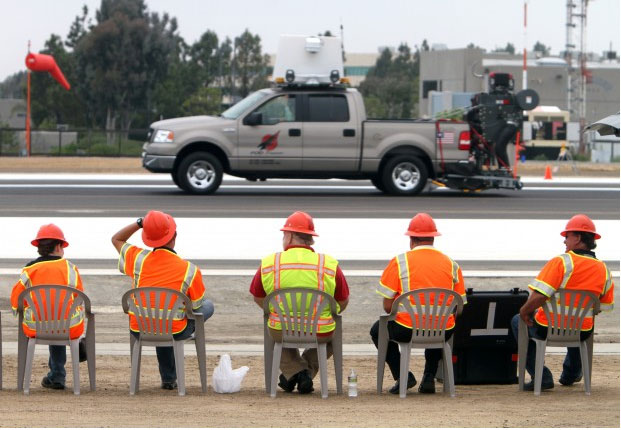
Image: A team of scientists and engineers from Trex Enterprises and the University of Illinois watch as Trex tests a radar device mounted on a pickup while on the runway at McClellan-Palomar Airport in Carlsbad on Tuesday. The purpose of the device is to locate and pick up small pieces of debris that damage aircraft during take-offs and landings. (Photo by Hayne Palmour IV – Staff photographer) 

CARLSBAD —- Stumble over a rock or a piece of junk on the sidewalk, and you might fall. But if an aircraft hits such debris, the consequences can be far more serious —- the 2000 fatal crash of the supersonic Concorde jet in Paris was blamed on metal lying on a runway. So airport employees regularly inspect the runways to make sure they’re clear of such debris. San Diego-based Trex Enterprises Corp. says it offers a better way than the human eye to find and remove this dangerous junk.

They’ve adapted a military technology that uses millimeter-length radio waves to identify what the aviation industry calls “foreign object debris,” and then remove it. Trex is testing its system at McClellan-Palomar Airport. This week, officials from the Federal Aviation Administration dropped by to see the system in action. By tracking and removing debris that can damage aircraft, Trex’s system can improve safety and lower aircraft insurance rates, said Grant Bishop, chief operations officer of Trex Aviation Corp., a subsidiary of the company.

Called FOD Finder, the truck-mounted system not only locates the debris, but also vacuums it up, Bishop said. The waves have one-tenth the energy of a cell phone’s radiation, he said. The military uses this technology to detect such obstacles as wires in the air that could entangle helicopters, said Bishop, a former commander of the U.S. Air Force’s 4th Fighter Squadron. Bishop flew F-16s and served in Operation Iraqi Freedom in 2003.

On the ground, the debris threatening aircraft can be just about anything —- lost tools, pavement fragments, gas caps or broken aircraft parts. For example, the Concorde passenger jet crash, which killed all 109 people on board, was caused by a metal strip that had fallen from another aircraft, according to a French investigation. Willie Vasquez, manager of Palomar Airport, said he’s impressed with what he has seen of Trex’s system. Large airports such as Los Angeles International Airport are most in need of improved debris detection, he said. “They (LAX) probably do 10 inspections a day,” Vasquez said. “Right now, it’s all done by the human eye, and these guys don’t have a lot of time in between all the flights. But this thing doesn’t get tired. It doesn’t matter whether it’s day or night.” Trex has been testing its system at Palomar Airport for months before the FAA visit this week to verify its accuracy, Bishop said. The airport is convenient and logistically easier to work from than the far-busier San Diego International Airport. Meanwhile, McClellan-Palomar is completing major upgrades visible to anyone who hasn’t been to the airport recently. These include a new building housing a gate for a startup service, California Pacific Airlines, preparing to begin operations as early as November. Vasquez said he’s showing the airport’s upgrades to other potential customers. On Tuesday morning, for example, he hosted a visit from Frontier Airlines.

Improved safety from Trex’s system, which costs $400,000, can make the airport even more desirable, Bishop said.
If Palomar Airport buys it, “they’re going to have one of the most advanced systems out here, saving people money and keeping them safe.” The FAA is testing three other types of detection systems, but Trex’s is the only one made in the United States, Bishop said. The others are made by companies in Britain, Israel and Singapore. Edwin E. Herricks, leader of the FAA’s performance assessment, said the others are based in fixed locations, at a tower, and scan the runways from the tower. Trex’s FOD Finder is the only mobile system being tested. The agency’s assessment should be done by the fall, said Herricks, coordinator of airport safety management at the Center for Excellence for Airport Technology at the University of Illinois at Urbana-Champaign.

Airports can then decide which debris-detection system to buy. The agency has left the decision up to each airport.
Trex also makes fixed-base and transportable FOD detectors, Bishop said. The transportable system is similar to the fixed system, but can be moved from one location to another. Airports aren’t being told which system to choose, Bishop said, but the FAA has a “buy-American” policy, including financial incentives.

Contact Trex Enterprises at www.trexenterprises.com or call 858-646-5553.

Call staff writer Bradley J. Fikes at 760-739-6641.
Read his blogs at bizblogs.nctimes.com.